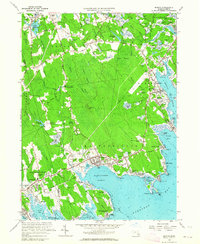
1962 Map of Marion
USGS Topo · Published 1964About this map
Cranberry Bog fields punctuate the lowlands of Plymouth County in the early 1960s, illustrating the agricultural heritage of Rochester, Marion, and Mattapoisett. The landscape is a dense network of freshwater swamps and tidal inlets, where Haskell Swamp and Bear Swamp drain toward the salt waters of Buzzards Bay. Along the coast, the villages are well-established maritime hubs, featuring landmarks like Tabor Academy and Ned Point.
Find a feature on this map
84 named features on this map. Tap any name to fly to it.
Don’t see what you’re looking for? This feature index may not catch every label — zoom into the map to look around manually.
Map Details
Editions of this 1962 Marion Map
This is the sole edition of this map. No revisions or reprints were ever made.
Other maps of this area

1885 · New Bedford
USGS Topo · 1:62,500

1885 · Middleboro
USGS Topo · 1:62,500

1886 · Falmouth
USGS Topo · 1:62,500

1886 · Plymouth
USGS Topo · 1:62,500

1888 · New Bedford
USGS Topo · 1:62,500

1888 · Falmouth
USGS Topo · 1:62,500

1888 · Middleboro
USGS Topo · 1:62,500

1889 · Plymouth
USGS Topo · 1:62,500

1893 · Middleboro
USGS Topo · 1:62,500

1893 · Falmouth
USGS Topo · 1:62,500