1888 Map of New Bedford
USGS Topo · Published 1888About this map
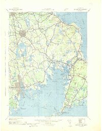
New Bedford serves as the industrial and maritime hub of this South Coast landscape in the late nineteenth century. The dense grid of the city faces Fairhaven across the Acushnet River, while three primary rail corridors, including the Fall River and New Bedford Railroad, converge on the harbor. The map documents a coastal economy defined by its maritime infrastructure, from the Clarks Point Light guarding the entrance to New Bedford Harbor to the small village of Oxford and the shipyards at Mattapoisett.
Find a feature on this map
97 named features on this map. Tap any name to fly to it.
Don’t see what you’re looking for? This feature index may not catch every label — zoom into the map to look around manually.
Map Details
Editions of this 1888 New Bedford Map
This is the sole edition of this map. No revisions or reprints were ever made.
Historical Maps of New Bedford Through Time
6 maps found