
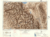
1947 Map of Mariposa
USGS Topo · Published 1948About this map
Sierra Nevada peaks and deep river canyons dominate this mid-century survey, which documents the High Sierra before the full expansion of post-war alpine tourism. The map detail highlights the rugged transition from the Merced River valley in the west to the high-desert terrain of the Owens River and White Mountains in the east. Yosemite National Park occupies the northwestern corner, featuring landmarks like the Glacier Point Hotel and the Crane Flat Ranger Station. The eastern slopes reveal a string of small settlements along the Southern Pacific rail line and U S 395, including Bishop, Laws, and Benton Station. Water management is a prominent theme, with major impoundments such as the Hetch Hetchy Reservoir, Lake Eleanor Reservoir, and the newly rising waters behind the Millerton Lake dam on the San Joaquin River. The map also preserves the footprint of high-altitude industry at the Casa Diablo Mine.
Find a feature on this map
192 named features on this map. Tap any name to fly to it.
Don’t see what you’re looking for? This feature index may not catch every label — zoom into the map to look around manually.
Map Details
Editions of this 1947 Mariposa Map
2 editions found
Other maps of this area

1891 · Big Trees
USGS Topo · 1:125,000

1893 · Sonora
USGS Topo · 1:125,000

1894 · Big Trees
USGS Topo · 1:125,000

1896 · Dardanelles
USGS Topo · 1:125,000

1896 · Sonora
USGS Topo · 1:125,000

1897 · Sonora
USGS Topo · 1:125,000

1897 · Big Trees
USGS Topo · 1:125,000

1897 · Yosemite
USGS Topo · 1:125,000

1898 · Dardanelles
USGS Topo · 1:125,000

1898 · Sonora
USGS Topo · 1:125,000
Featured Places
- Mammoth Lakes, CA
- Oakhurst, CA
- Coarsegold, CA
- Bishop, CA
- Dixon Lane–Meadow Creek, Dixon Lane-Meadow Creek