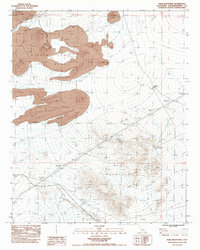
1983 Map of Marl Mountains
USGS Topo · Published 1983About this map
Marl Mountains and the basaltic flows of the Lava Beds define this segment of the Mojave Desert in the early 1980s. The landscape is a study in volcanic geology, centered on a prominent Cinder Cone and the transition into the broad, sloping profile of Cima Dome. Human activity is marked by resource extraction and desert survival, evidenced by a Cinder Pit in the northern flows and several Prospects and a Shaft further south.
Find a feature on this map
20 named features on this map. Tap any name to fly to it.
Don’t see what you’re looking for? This feature index may not catch every label — zoom into the map to look around manually.
Map Details
Editions of this 1983 Marl Mountains Map
This is the sole edition of this map. No revisions or reprints were ever made.
Other maps of this area

1910 · Ivanpah
USGS Topo · 1:250,000

1912 · Ivanpah
USGS Topo · 1:250,000

1942 · Ivanpah
USGS Topo · 1:250,000

1947 · Kingman
USGS Topo · 1:250,000

1948 · Kingman
USGS Topo · 1:250,000

1954 · Kingman
USGS Topo · 1:250,000

1955 · Kingman
USGS Topo · 1:250,000

1955 · Mescal Range
USGS Topo · 1:62,500

1955 · Kelso
USGS Topo · 1:62,500

1956 · Halloran Spring
USGS Topo · 1:62,500