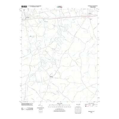
2010 Map of Marshville
USGS Topo · Published 2010About this map
Marshville and Peachland anchor the northern landscape of this Union County survey, connected by a network of rural routes and the rolling drainage of the Piedmont. The terrain is defined by the expansive reaches of Lanes Creek and Brown Creek, which gather numerous named tributaries like Black Jack Branch and Wide Mouth Branch. Local water management is evident at Stegall Lake and Marsh Lake, each with its associated dam structures.
Find a feature on this map
71 named features on this map. Tap any name to fly to it.
Don’t see what you’re looking for? This feature index may not catch every label — zoom into the map to look around manually.
Map Details
Editions of this 2010 Marshville Map
This is the sole edition of this map. No revisions or reprints were ever made.
Other maps of this area

1941 · Spartanburg
USGS Topo · 1:250,000

1953 · Spartanburg
USGS Topo · 1:250,000

1953 · Charlotte
USGS Topo · 1:250,000

1954 · Charlotte
USGS Topo · 1:250,000

1960 · Charlotte
USGS Topo · 1:250,000

1960 · Spartanburg
USGS Topo · 1:250,000

1962 · Charlotte
USGS Topo · 1:250,000

1963 · Spartanburg
USGS Topo · 1:250,000

1964 · Spartanburg
USGS Topo · 1:250,000
1970 · Watson
USGS Topo · 1:24,000