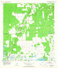
1954 Map of Masaryktown
USGS Topo · Published 1966About this map
The agricultural and transit corridor of southern Hernando County comes into focus in this mid-1950s survey, centered on the unique ethnic settlement of Masaryktown. Established in the 1920s by Slovak and Czech immigrants, the community is shown here as a grid of small farms and residential blocks adjacent to the Seaboard Air Line tracks. To the north, the Brooksville Airport occupies a significant portion of the landscape, while the Florida State Prison Camp sits isolated nearby. The southern portion of the map transitions into the lakelands of Pasco County, where Loyce and Big Fish Lake sit among a landscape dotted with numerous unnamed ponds and depressions. This map preserves the locations of local landmarks such as McGeachy Cem and Garden Grove, offering a detailed look at the region's rural infrastructure before significant modern expansion.
Find a feature on this map
18 named features on this map. Tap any name to fly to it.
Don’t see what you’re looking for? This feature index may not catch every label — zoom into the map to look around manually.
Map Details
Editions of this 1954 Masaryktown Map
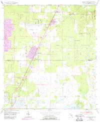
3 editions found
Other maps of this area

1954 · Spring Lake
USGS Topo · 1:24,000

1954 · Ehren
USGS Topo · 1:24,000

1954 · San Antonio
USGS Topo · 1:24,000

1954 · Fivay
USGS Topo · 1:24,000

1954 · Brooksville
USGS Topo · 1:24,000

1954 · Masaryktown
USGS Topo · 1:24,000

1954 · Brooksville SE
USGS Topo · 1:24,000

1954 · Weekiwachee Springs
USGS Topo · 1:24,000

1954 · Port Richey NE
USGS Topo · 1:24,000

1955 · Plant City
USGS Topo · 1:250,000