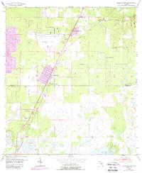
1954 Map of Masaryktown
USGS Topo · Published 1988About this map
Masaryktown serves as the focal point of this 1950s survey, reflecting its origins as a planned agricultural settlement. The map illustrates a landscape of flatlands and scattered basins along the Hernando Co Pasco Co border, where the grid pattern of the town contrasts with the surrounding rural terrain. Transportation and infrastructure are central to the area's mid-century character, evidenced by the Brooksville Airport and the rail line serving Powell (Station).
Find a feature on this map
16 named features on this map. Tap any name to fly to it.
Don’t see what you’re looking for? This feature index may not catch every label — zoom into the map to look around manually.
Map Details
Editions of this 1954 Masaryktown Map
3 editions found
Other maps of this area

1954 · Spring Lake
USGS Topo · 1:24,000

1954 · Ehren
USGS Topo · 1:24,000

1954 · San Antonio
USGS Topo · 1:24,000

1954 · Fivay
USGS Topo · 1:24,000

1954 · Brooksville
USGS Topo · 1:24,000

1954 · Masaryktown
USGS Topo · 1:24,000

1954 · Brooksville SE
USGS Topo · 1:24,000

1954 · Weekiwachee Springs
USGS Topo · 1:24,000

1954 · Port Richey NE
USGS Topo · 1:24,000

1955 · Plant City
USGS Topo · 1:250,000