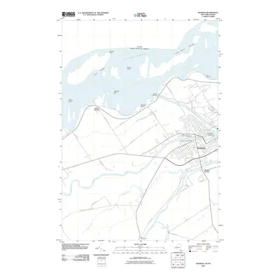
2010 Map of Massena
USGS Topo · Published 2010About this map
The industrial and riverine character of the United States-Canada border is defined by the massive water control infrastructure near Massena. This survey captures the complex hydraulics of the Saint Lawrence Seaway, where the Massena Power Canal and Wiley Dondero Canal intersect with natural features like the Grass River and Raquette River. The landscape is a mix of heavy utility, seen in the Massena Intake Dam and Dike Number 1, and established local history. Several burial grounds, including Adath Cemetery and the West Orvis Street Cemetery, are clustered near the town center. To the south, Massena Springs and Kent Mill Cemetery sit along the winding course of Plum Brook, while the northern reaches are dominated by Croil Islands and Lake Saint Lawrence.
Find a feature on this map
45 named features on this map. Tap any name to fly to it.
Don’t see what you’re looking for? This feature index may not catch every label — zoom into the map to look around manually.
Map Details
Editions of this 2010 Massena Map
This is the sole edition of this map. No revisions or reprints were ever made.
Other maps of this area

1905 · Waddington
USGS Topo · 1:62,500

1906 · Massena
USGS Topo · 1:62,500

1907 · Massena
USGS Topo · 1:62,500

1942 · Chase Mills
USGS Topo · 1:24,000

1942 · Norfolk
USGS Topo · 1:24,000

1942 · Barnhart Island
USGS Topo · 1:24,000

1942 · Massena
USGS Topo · 1:24,000

1943 · Barnhart Island
USGS Topo · 1:31,680
1943 · Massena
USGS Topo · 1:31,680
1943 · Chase Mills
USGS Topo · 1:31,680