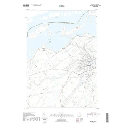
2019 Map of Massena
USGS Topo · Published 2019About this map
Massena occupies a strategic position at the confluence of northern New York's major waterways, where the Grass River and Raquette River flow parallel toward the international border. This modern topography illustrates the complex water management of the region, featuring the Saint Lawrence Seaway and the expansive Lake St. Lawrence created by hydroelectric development. The village's industrial and residential footprint extends south to Massena Springs, while the surrounding landscape is marked by historical burial grounds such as Kent Mill Cem and Pine Grove Cem. Near the northern boundary, the Canada-United States border bisects the water, leaving Croil Island and the Long Sault Islands as significant landmasses in the river channel. The dense grid of Massena's streets, including Saint Regis Blvd, contrasts with the outlying rural roads like Ridge Road in Louisville, reflecting a century of growth as a regional hub.
Find a feature on this map
96 named features on this map. Tap any name to fly to it.
Don’t see what you’re looking for? This feature index may not catch every label — zoom into the map to look around manually.
Map Details
Editions of this 2019 Massena Map
This is the sole edition of this map. No revisions or reprints were ever made.
Other maps of this area

1905 · Waddington
USGS Topo · 1:62,500

1906 · Massena
USGS Topo · 1:62,500

1907 · Massena
USGS Topo · 1:62,500

1942 · Chase Mills
USGS Topo · 1:24,000

1942 · Norfolk
USGS Topo · 1:24,000

1942 · Barnhart Island
USGS Topo · 1:24,000

1942 · Massena
USGS Topo · 1:24,000

1943 · Barnhart Island
USGS Topo · 1:31,680
1943 · Massena
USGS Topo · 1:31,680
1943 · Chase Mills
USGS Topo · 1:31,680