1982 Map of Mathias Point
USGS Topo · Published 1983About this map
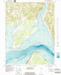
Cedar Point Neck and Mathias Point Neck dominate this Potomac River landscape, where the Maryland and Virginia border follows the deep-water channels. This early 1980s data reflects a mix of traditional rural Maryland life and Cold War-era scientific expansion, with the U S Naval Research Laboratory and Harry Diamond Laboratories occupying significant riverfront acreage. Small communities such as McConchie, Welcome, and Brentland are connected by narrow roads like Brentland Road and Taylor Neck Rd.
Find a feature on this map
55 named features on this map. Tap any name to fly to it.
Don’t see what you’re looking for? This feature index may not catch every label — zoom into the map to look around manually.
Map Details
Editions of this 1982 Mathias Point Map
This is the sole edition of this map. No revisions or reprints were ever made.
Other maps of this area

1889 · Fredericksburg
USGS Topo · 1:125,000

1890 · Mt. Vernon
USGS Topo · 1:125,000

1891 · Mt. Vernon
USGS Topo · 1:125,000

1892 · Fredericksburg
USGS Topo · 1:125,000

1892 · Brandywine
USGS Topo · 1:62,500

1894 · Wicomico
USGS Topo · 1:62,500

1894 · Fredericksburg
USGS Topo · 1:125,000

1894 · Mt. Vernon
USGS Topo · 1:125,000

1895 · Wicomico
USGS Topo · 1:62,500

1895 · Brandywine
USGS Topo · 1:62,500