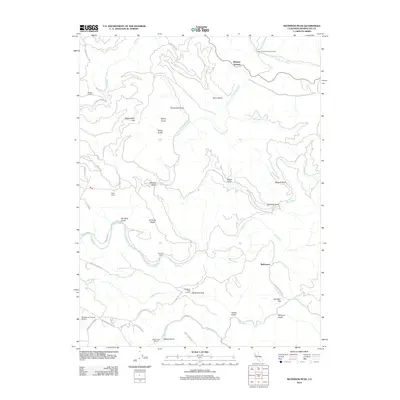
2012 Map of Mathison Peak
USGS Topo · Published 2012About this map
The Big River and Albion River drainage basins define this coastal California landscape, where timber history and ranching legacies remain visible through local place names. Rising to the south, Mathison Peak and the Mathison Peak Lookout stand as prominent landmarks overlooking a series of deeply etched gulches, including Manly Gulch, Peterson Gulch, and Kaisen Gulch. Small settlements and family holdings such as Caspar Orchard, Reep Ranch, and MacDonalds Ranch are connected by a network of winding roads like Little Lake Rd and Comptche Ukiah Rd.
Find a feature on this map
50 named features on this map. Tap any name to fly to it.
Don’t see what you’re looking for? This feature index may not catch every label — zoom into the map to look around manually.
Map Details
Editions of this 2012 Mathison Peak Map
This is the sole edition of this map. No revisions or reprints were ever made.
Other maps of this area

1920 · Glenblair
USGS Topo · 1:62,500

1920 · Fort Bragg
USGS Topo · 1:62,500

1943 · Glenblair
USGS Topo · 1:62,500

1943 · Fort Bragg
USGS Topo · 1:62,500

1943 · Albion
USGS Topo · 1:62,500

1943 · Navarro
USGS Topo · 1:62,500

1944 · Saddle Point
USGS Topo · 1:62,500

1957 · Ukiah
USGS Topo · 1:250,000

1960 · Ukiah
USGS Topo · 1:250,000
1960 · Elk
USGS Topo · 1:24,000