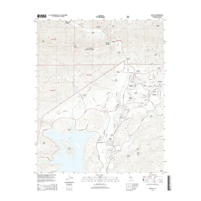
2015 Map of Matilija
USGS Topo · Published 2015About this map
Ojai and the surrounding Ojai Valley dominate this survey of the Ventura County highlands, illustrating a landscape defined by sharp elevation changes and managed wilderness. The valley floor is tightly clustered with residential developments like Meiners Oaks, Mira Monte, and Arbolada, while the northern portion of the map is dominated by the Los Padres National Forest and the peaks of the Santa Ynez Mountains. The hydrological network is clearly defined by the Ventura River and its various forks, feeding into the large expanse of Lake Casitas to the southwest, which features the prominent Main Island. Historically significant sites, including Vickers Hot Springs and Matilija Springs, point to the area's legacy of thermal waters. Local history and genealogy are anchored by the Nordhoff Cemetery and Ojai Cemetery, while the presence of Krotona Hill reflects the unique cultural and educational institutions that have historically shaped this region's character.
Find a feature on this map
85 named features on this map. Tap any name to fly to it.
Don’t see what you’re looking for? This feature index may not catch every label — zoom into the map to look around manually.
Map Details
Editions of this 2015 Matilija Map
This is the sole edition of this map. No revisions or reprints were ever made.
Other maps of this area

1903 · Santa Paula
USGS Topo · 1:62,500

1903 · Mt. Pinos
USGS Topo · 1:125,000

1904 · Ventura
USGS Topo · 1:62,500

1941 · Ventura
USGS Topo · 1:62,500

1942 · Santa Paula
USGS Topo · 1:62,500

1942 · Wheeler Springs
USGS Topo · 1:24,000

1943 · Old Man Mountain
USGS Topo · 1:24,000

1943 · Lion Canyon
USGS Topo · 1:24,000

1943 · Wheeler Springs
USGS Topo · 1:24,000
1944 · Wheeler Springs
USGS Topo · 1:31,680