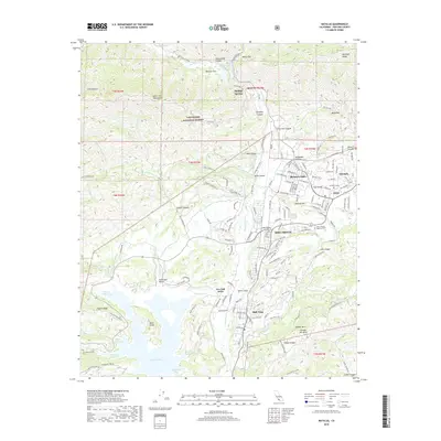
2018 Map of Matilija
USGS Topo · Published 2018About this map
Lake Casitas dominates the southern landscape of this Ojai Valley survey, its complex shoreline defined by fingers like Wadleigh Arm and Station Canyon Arm. The water's edge reaches toward the residential growth of Oak View and Live Oak Acres, while the primary settlement of Ojai sits to the east, bordered by the established neighborhoods of Arbolada and Meiners Oaks. The map reveals a transition from these valley floors to the steep slopes of the Santa Ynez Mountains and Sulphur Mtn.
Find a feature on this map
98 named features on this map. Tap any name to fly to it.
Don’t see what you’re looking for? This feature index may not catch every label — zoom into the map to look around manually.
Map Details
Editions of this 2018 Matilija Map
This is the sole edition of this map. No revisions or reprints were ever made.
Other maps of this area

1903 · Santa Paula
USGS Topo · 1:62,500

1903 · Mt. Pinos
USGS Topo · 1:125,000

1904 · Ventura
USGS Topo · 1:62,500

1941 · Ventura
USGS Topo · 1:62,500

1942 · Santa Paula
USGS Topo · 1:62,500

1942 · Wheeler Springs
USGS Topo · 1:24,000

1943 · Old Man Mountain
USGS Topo · 1:24,000

1943 · Lion Canyon
USGS Topo · 1:24,000

1943 · Wheeler Springs
USGS Topo · 1:24,000
1944 · Wheeler Springs
USGS Topo · 1:31,680