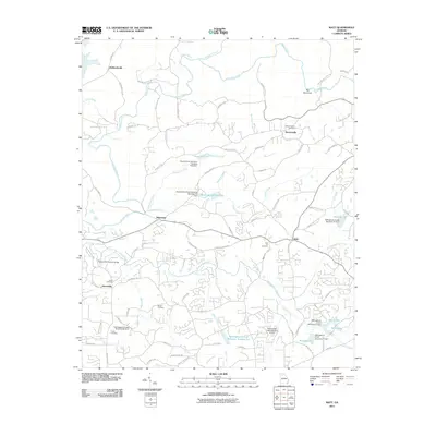
2011 Map of Matt
USGS Topo · Published 2011About this map
Pooles Mill Covered Bridge spans Settingdown Creek, anchoring a landscape where the river-rich terrain of north Georgia meets modern watershed management. The north is defined by the winding Etowah River and its confluence with Amicalola Creek, while the southern reaches are marked by a series of flood control structures and reservoirs, including Settingdown Creek Reservoir Number Two and Twin Lakes. Several smaller, localized settlements such as Matt, Barrettsville, and Heardville serve as regional hubs connected by a network of winding county roads like Kelly Bridge Rd. For family historians, the sheet is exceptionally detailed with burial sites including Heard Cemetery, Sewell Cemetery, and Salem Church Cemetery, offering a precise record of local genealogy and community centers in this part of Forsyth County.
Find a feature on this map
89 named features on this map. Tap any name to fly to it.
Don’t see what you’re looking for? This feature index may not catch every label — zoom into the map to look around manually.
Map Details
Editions of this 2011 Matt Map
This is the sole edition of this map. No revisions or reprints were ever made.
Other maps of this area

1890 · Suwanee
USGS Topo · 1:125,000

1894 · Suwanee
USGS Topo · 1:125,000

1926 · Tate
USGS Topo · 1:62,500

1928 · Tate
USGS Topo · 1:62,500

1955 · Rome
USGS Topo · 1:250,000

1956 · Birmingham
USGS Topo · 1:24,000

1958 · Rome
USGS Topo · 1:250,000

1961 · Rome
USGS Topo · 1:250,000

1963 · Rome
USGS Topo · 1:250,000
1964 · Juno
USGS Topo · 1:24,000