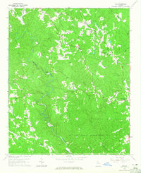
1964 Map of Juno
USGS Topo · Published 1965About this map
Amicalola Creek and its many tributaries, including Cochrans Creek and Sweetwater Creek, define the topography of this portion of Dawson and Lumpkin counties. In the mid-1960s, the landscape was a patchwork of dense woodlands and small agrarian settlements. Rural life centered on a network of country churches such as McKees Chapel and Pleasant Grove Ch, alongside local landmarks like the Lookout Tower and a Covered Bridge spanning the creek waters.
Find a feature on this map
26 named features on this map. Tap any name to fly to it.
Don’t see what you’re looking for? This feature index may not catch every label — zoom into the map to look around manually.
Map Details
Editions of this 1964 Juno Map
Other maps of this area

1888 · Ellijay
USGS Topo · 1:125,000

1890 · Suwanee
USGS Topo · 1:125,000

1892 · Ellijay
USGS Topo · 1:125,000

1894 · Suwanee
USGS Topo · 1:125,000

1898 · Ellijay
USGS Topo · 1:125,000

1911 · Ellijay
USGS Topo · 1:125,000

1926 · Tate
USGS Topo · 1:62,500

1928 · Tate
USGS Topo · 1:62,500
1950 · Campbell Mtn
USGS Topo · 1:24,000

1955 · Rome
USGS Topo · 1:250,000