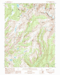
1990 Map of Matterhorn Peak
USGS Topo · Published 1990About this map
Matterhorn Peak and the high granite spires of the Sawtooth Ridge define this remote section of the High Sierra, situated along the boundary between Mono and Tuolumne counties. The landscape is characterized by a series of high-altitude glacial basins and prominent summits such as Whorl Mountain and Finger Peaks. This 1990 provisional survey documents the extensive trail networks and wilderness areas within Yosemite National Park and the adjacent Toiyabe National Forest.
Find a feature on this map
52 named features on this map. Tap any name to fly to it.
Don’t see what you’re looking for? This feature index may not catch every label — zoom into the map to look around manually.
Map Details
Editions of this 1990 Matterhorn Peak Map
This is the sole edition of this map. No revisions or reprints were ever made.
Other maps of this area

1896 · Dardanelles
USGS Topo · 1:125,000

1897 · Yosemite
USGS Topo · 1:125,000

1898 · Dardanelles
USGS Topo · 1:125,000

1900 · Yosemite
USGS Topo · 1:125,000

1901 · Mt. Lyell
USGS Topo · 1:125,000

1903 · Yosemite
USGS Topo · 1:125,000

1909 · Yosemite
USGS Topo · 1:125,000

1909 · Bridgeport
USGS Topo · 1:125,000

1911 · Bridgeport
USGS Topo · 1:125,000

1920 · Bridgeport
USGS Topo · 1:125,000