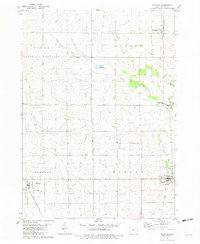
1981 Map of Maynard
USGS Topo · Published 1982About this map
Maynard and Westgate anchor this agricultural landscape in Fayette County during the early 1980s, a period when the regional economy remained deeply tied to the land and the rail. The Chicago and North Western corridor bisects the terrain, connecting small elevators and depots such as Randalia. Local civic life is marked by numerous country landmarks, including Union Ch and Hope Ch, alongside community centers like the West Central High Sch. The drainage of the Volga River and its tributaries, including the North Branch Volga River and Little Volga River, dictates the placement of recreation areas like Twin Bridges County Park. Notable for genealogists are the well-defined boundaries of Banks, Center, Fremont, and Harlan townships, which provide a clear framework for locating family farms and several rural cemeteries.
Find a feature on this map
27 named features on this map. Tap any name to fly to it.
Don’t see what you’re looking for? This feature index may not catch every label — zoom into the map to look around manually.
Map Details
Editions of this 1981 Maynard Map
This is the sole edition of this map. No revisions or reprints were ever made.
Other maps of this area

1901 · Oelwein
USGS Topo · 1:125,000

1954 · Waterloo
USGS Topo · 1:250,000

1955 · Waterloo
USGS Topo · 1:250,000

1959 · Dubuque
USGS Topo · 1:250,000

1961 · Dubuque
USGS Topo · 1:250,000

1962 · Dubuque
USGS Topo · 1:250,000

1971 · Sumner
USGS Topo · 1:24,000

1971 · Alpha
USGS Topo · 1:24,000

1971 · Fairbank
USGS Topo · 1:24,000

1976 · Dubuque
USGS Topo · 1:250,000