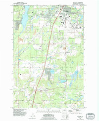
1990 Map of Maytown
USGS Topo · Published 1995About this map
Maytown and the surrounding Thurston County landscape are defined by a mix of glacial prairies and strategic transportation corridors. In the north, the burgeoning infrastructure of Tumwater borders the Olympia Airport, while the central portion of the map transition into the wetlands and woodlots of Bush Prairie. The presence of both the Burlington Northern and Union Pacific rail lines illustrates the region's importance as a Pacific Northwest transit hub, connecting coastal ports with inland markets.
Find a feature on this map
42 named features on this map. Tap any name to fly to it.
Don’t see what you’re looking for? This feature index may not catch every label — zoom into the map to look around manually.
Map Details
Editions of this 1990 Maytown Map
This is the sole edition of this map. No revisions or reprints were ever made.
Other maps of this area

1916 · Chehalis
USGS Topo · 1:125,000

1937 · Olympia
USGS Topo · 1:62,500

1939 · Shelton
USGS Topo · 1:62,500

1940 · Tenino
USGS Topo · 1:62,500

1941 · Gate
USGS Topo · 1:62,500

1944 · Tenino
USGS Topo · 1:62,500

1949 · Tenino
USGS Topo · 1:62,500

1949 · Olympia
USGS Topo · 1:62,500

1953 · Hoquiam
USGS Topo · 1:250,000

1953 · Rochester
USGS Topo · 1:62,500