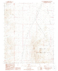
1989 Map of McCullough Mountain NE
USGS Topo · Published 1990About this map
The Mc Cullough Range and the Highland Range dominate this desert landscape in Clark County, showing a region managed for wildlife and natural resources in the late 1980s. A significant portion of the terrain is designated as the Crucial Bighorn Habitat Area, emphasizing the ecological importance of these mountain slopes. In the lower elevations, the Eldorado Valley spreads to the northeast, crossed by numerous Trans Lines that suggest the area's role in the regional power grid. Scattered evidence of mineral exploration appears in the eastern foothills near a Prospect Line, while isolated water sources like a lone Spring and a Guzzler provide rare relief in the arid environment. A distinctive peak known as Castle stands as a prominent landmark within the Highland Range, marking the transition between the high peaks and the valley floor.
Find a feature on this map
13 named features on this map. Tap any name to fly to it.
Don’t see what you’re looking for? This feature index may not catch every label — zoom into the map to look around manually.
Map Details
Editions of this 1989 McCullough Mountain NE Map
This is the sole edition of this map. No revisions or reprints were ever made.
Other maps of this area

1886 · Camp Mohave
USGS Topo · 1:250,000

1892 · Camp Mohave
USGS Topo · 1:250,000

1910 · Ivanpah
USGS Topo · 1:250,000

1912 · Ivanpah
USGS Topo · 1:250,000

1926 · Nelson
USGS Topo · 1:96,000

1942 · Camp Mohave
USGS Topo · 1:250,000

1942 · Ivanpah
USGS Topo · 1:250,000

1947 · Kingman
USGS Topo · 1:250,000

1948 · Kingman
USGS Topo · 1:250,000

1954 · Kingman
USGS Topo · 1:250,000