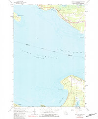
1964 Map of McGulpin Point
USGS Topo · Published 1984About this map
Mc Gulpin Point stands at the northernmost reach of the Lower Peninsula, overlooking the deep waters of the Straits of Mackinac. This mid-century survey documents the strategic coastal geography where Lake Michigan meets the passage to Lake Huron. The area is defined by its transition from the settled streets of Mackinaw City to the timbered reaches of the Mackinaw State Forest. To the south, French Farm Lake and the marshy inlet of Cecil Bay offer a glimpse into the natural drainage patterns of Emmet County before later development modified the shoreline.
Find a feature on this map
33 named features on this map. Tap any name to fly to it.
Don’t see what you’re looking for? This feature index may not catch every label — zoom into the map to look around manually.
Map Details
Editions of this 1964 McGulpin Point Map
2 editions found
Other maps of this area

1931 · St Ignace NW
USGS Topo · 1:31,680

1931 · Moran NE
USGS Topo · 1:31,680

1948 · Moran NE
USGS Topo · 1:31,680

1948 · Moran NW
USGS Topo · 1:31,680

1955 · Cheboygan
USGS Topo · 1:250,000

1957 · Mullett Lake
USGS Topo · 1:62,500

1958 · Cheboygan
USGS Topo · 1:250,000

1958 · Pellston
USGS Topo · 1:62,500

1964 · Big Stone Bay
USGS Topo · 1:24,000
1964 · Moran
USGS Topo · 1:24,000