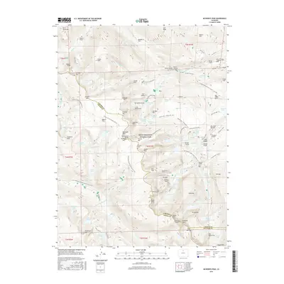
2016 Map of McHenrys Peak
USGS Topo · Published 2016About this map
McHenrys Peak and the surrounding high-altitude terrain of Rocky Mountain National Park dominate this 2016 survey along the boundary of Larimer and Grand Counties. The map documents an intricate network of alpine hydrology and engineering, including the Eureka Ditch and the subterranean path of the Alva B Adams Tunnel, which moves water across the Continental Divide. High-elevation landmarks such as the Doctor Thornton R Sampson Grave and J P Chitwood Grave provide unique genealogical touchpoints within this protected wilderness. The landscape is defined by its glaciated features, from the sharp profile of The Sharkstooth to the basins of Bear Lake and Bierstadt Lake. A complex system of footpaths, including the Continental Divide National Scenic Trail and the Ute Trail E, connects these remote points, reflecting the long-standing recreational and migratory importance of these mountain passes.
Find a feature on this map
133 named features on this map. Tap any name to fly to it.
Don’t see what you’re looking for? This feature index may not catch every label — zoom into the map to look around manually.
Map Details
Editions of this 2016 McHenrys Peak Map
This is the sole edition of this map. No revisions or reprints were ever made.
Other maps of this area
1915 · Longs Peak
USGS Topo · 1:125,000
1919 · Rocky Mountain National Park
USGS Topo · 1:125,000
1954 · Greeley
USGS Topo · 1:250,000
1957 · Greeley
USGS Topo · 1:250,000
1957 · Mc Henrys Peak
USGS Topo · 1:24,000
1957 · Trail Ridge
USGS Topo · 1:24,000
1957 · Allens Park
USGS Topo · 1:24,000
1957 · Longs Peak
USGS Topo · 1:24,000
1957 · Estes Park
USGS Topo · 1:24,000
1958 · Greeley
USGS Topo · 1:250,000