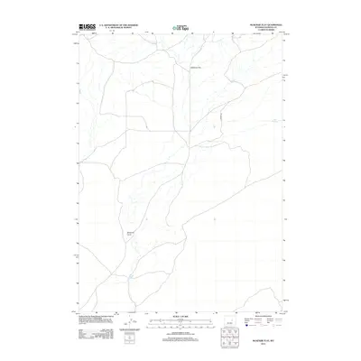
2012 Map of McKenzie Flat
USGS Topo · Published 2012About this map
McKenzie Flat defines the high plateau of Natrona County, showing the sparse water resources and expansive cattle country typical of this part of Wyoming. In the early 21st century, this land remains largely undeveloped, characterized by seasonal drainage patterns and isolated water sources like Sand Springs and Mud Spring. The terrain is shaped by the long descent of McKenzie Draw, which cuts through the central landscape. Modern access is limited to a few arterial routes such as E Ormsby Rd, reflecting the enduring rural character of the region. This survey captures the intersection of traditional rangeland with modern topographic precision, detailing the subtle elevation changes that govern water flow across the flat.
Find a feature on this map
5 named features on this map. Tap any name to fly to it.
Don’t see what you’re looking for? This feature index may not catch every label — zoom into the map to look around manually.
Map Details
Editions of this 2012 McKenzie Flat Map
This is the sole edition of this map. No revisions or reprints were ever made.
Other maps of this area
1949 · Campbell Hill
USGS Topo · 1:24,000
1949 · Pratts Soda Lakes
USGS Topo · 1:24,000
1950 · Campbell Hill
USGS Topo · 1:24,000
1950 · Pratts Soda Lakes
USGS Topo · 1:24,000
1951 · The Reefs
USGS Topo · 1:24,000

1955 · Arminto
USGS Topo · 1:250,000

1955 · Casper
USGS Topo · 1:250,000

1958 · Casper
USGS Topo · 1:250,000

1958 · Arminto
USGS Topo · 1:250,000
1959 · Ormsby Draw
USGS Topo · 1:62,500