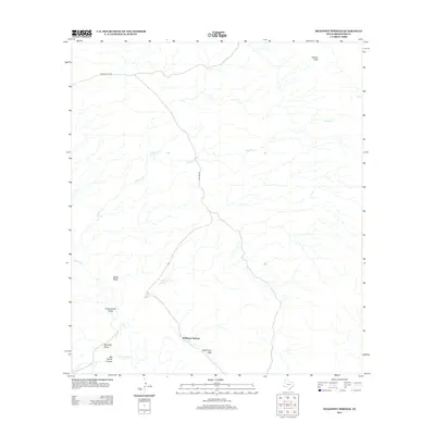
2012 Map of McKinney Springs
USGS Topo · Published 2012About this map
McKinney Springs and the surrounding desert landscape of Brewster County are defined by a network of critical water sources and rugged transit routes. This 2012 survey reveals a terrain where survival relied on isolated points like Muskhog Spring and McKinney Spring. The infrastructure is dominated by historic thoroughfares such as Old Ore Rd and Dagger Flat Rd, which navigate the elevation changes between Black Peaks and the McKinney Hills. Drainage patterns are clearly marked by the intermittent flows of Tornillo Cr, Hannold Draw, and Big Yellow Arroyo, illustrating the complex hydrology of this arid region. The map also identifies prominent landmarks like Stuarts Peak and the settlement of Javalina, providing a detailed look at the geographic character of this West Texas environment.
Find a feature on this map
14 named features on this map. Tap any name to fly to it.
Don’t see what you’re looking for? This feature index may not catch every label — zoom into the map to look around manually.
Map Details
Editions of this 2012 McKinney Springs Map
This is the sole edition of this map. No revisions or reprints were ever made.
Other maps of this area

1903 · Chisos Mountains
USGS Topo · 1:125,000

1905 · Chisos Mountains
USGS Topo · 1:125,000

1917 · Bone Spring
USGS Topo · 1:62,500

1918 · Bone Spring
USGS Topo · 1:125,000

1918 · Bone Spring
USGS Topo · 1:62,500

1919 · Maravillas Canyon
USGS Topo · 1:62,500

1920 · Bone Spring
USGS Topo · 1:62,500

1930 · Stillwell Creek
USGS Topo · 1:62,500

1959 · Emory Peak
USGS Topo · 1:250,000

1965 · Emory Peak
USGS Topo · 1:250,000