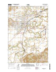
2014 Map of McMinnville
USGS Topo · Published 2014About this map
McMinnville serves as the central hub for this 2014 survey of the Yamhill Valley, where the confluence of several water bodies shapes the local landscape. The town is anchored by Linfield Coll and surrounded by a network of smaller agricultural communities including Saint Joseph, Whiteson, and Eola Village. The map traces the winding paths of the Yamhill River and South Yamhill River, which carve through the fertile terrain alongside the Amity Hills and Walnut Hill. Numerous reservoirs like Peavey Reservoir and Hawn Cr Reservoir dot the countryside, indicating the managed water resources vital to the region's farms and orchards. For local historians, the sheet provides exact locations for several burial sites, including the Masonic Cem, Saint James Cem, and the more isolated Taylor Cem. Infrastructure such as the Whiteson Bridge and the Watts Landing Airport illustrate the modern transportation framework connecting these rural settlements.
Find a feature on this map
153 named features on this map. Tap any name to fly to it.
Don’t see what you’re looking for? This feature index may not catch every label — zoom into the map to look around manually.
Map Details
Editions of this 2014 McMinnville Map
This is the sole edition of this map. No revisions or reprints were ever made.
Other maps of this area

1924 · Mc Minnville
USGS Topo · 1:48,000

1926 · Mc Minnville
USGS Topo · 1:62,500

1940 · McMinnville
USGS Topo · 1:62,500

1941 · Yamhill
USGS Topo · 1:62,500

1942 · Sheridan
USGS Topo · 1:62,500

1942 · Yamhill
USGS Topo · 1:62,500

1942 · Fairdale
USGS Topo · 1:62,500

1948 · Vancouver
USGS Topo · 1:250,000

1950 · Vancouver
USGS Topo · 1:250,000

1950 · Vancouver
USGS Topo · 1:250,000