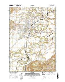
2017 Map of McMinnville
USGS Topo · Published 2017About this map
McMinnville and the surrounding Yamhill County landscape are defined by the convergence of the North Yamhill River and South Yamhill River. The map shows a region of established agricultural and urban development, where the city center is balanced by outlying settlements like Saint Joseph to the northeast and Whiteson to the south. Historically significant sites for genealogists include Masonic Cem, Saint James Cem, and the rural Taylor Cem located near the Amity Hills. Transportation and water management are prominent, from the Mc Minnville Municipal Airport to several small reservoirs like the McMinnville Reservoirs and Kauer Reservoir. The presence of landmarks such as Whiteson Bridge and Watts Landing suggests the enduring importance of river crossings and drainage in this fertile valley landscape.
Find a feature on this map
168 named features on this map. Tap any name to fly to it.
Don’t see what you’re looking for? This feature index may not catch every label — zoom into the map to look around manually.
Map Details
Editions of this 2017 McMinnville Map
This is the sole edition of this map. No revisions or reprints were ever made.
Other maps of this area

1924 · Mc Minnville
USGS Topo · 1:48,000

1926 · Mc Minnville
USGS Topo · 1:62,500

1940 · McMinnville
USGS Topo · 1:62,500

1941 · Yamhill
USGS Topo · 1:62,500

1942 · Sheridan
USGS Topo · 1:62,500

1942 · Yamhill
USGS Topo · 1:62,500

1942 · Fairdale
USGS Topo · 1:62,500

1948 · Vancouver
USGS Topo · 1:250,000

1950 · Vancouver
USGS Topo · 1:250,000

1950 · Vancouver
USGS Topo · 1:250,000