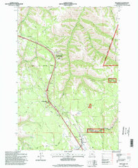
1995 Map of Meacham
USGS Topo · Published 1998About this map
Meacham serves as a central point in this late-twentieth-century study of the Blue Mountains, where the historic Union Pacific railroad corridor winds through the deep canyons of the Umatilla National Forest. The landscape is defined by its transit history and resource management, following the high ground of Telephone Ridge and Light Ridge. This map illustrates the intersection of public lands and indigenous territory, clearly marking the Umatilla Indian Reservation Boundary as it cuts across the headwaters of North Fork McKay Creek. For those interested in the development of Pacific Northwest infrastructure, the map preserves the locations of vital waypoints like Emigrant Springs State Park and the Blue Mountain Forest Wayside, alongside industrial markers such as a pumphouse and several gravel pits that supported the mountain crossings.
Find a feature on this map
34 named features on this map. Tap any name to fly to it.
Don’t see what you’re looking for? This feature index may not catch every label — zoom into the map to look around manually.
Map Details
Editions of this 1995 Meacham Map
This is the sole edition of this map. No revisions or reprints were ever made.
Other maps of this area

1935 · Pendleton
USGS Topo · 1:125,000

1953 · Pendleton
USGS Topo · 1:250,000

1956 · Pendleton
USGS Topo · 1:250,000

1963 · Meacham Lake
USGS Topo · 1:24,000

1964 · Thorn Hollow
USGS Topo · 1:24,000

1964 · Duncan
USGS Topo · 1:24,000

1964 · Gibbon
USGS Topo · 1:24,000

1964 · Huron
USGS Topo · 1:24,000

1964 · Meacham
USGS Topo · 1:24,000

1966 · Cabbage Hill
USGS Topo · 1:24,000