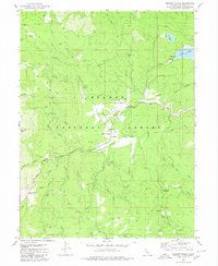
1980 Map of Meadow Valley
USGS Topo · Published 1980About this map
Meadow Valley and the historic settlement of Spanish Ranch serve as the primary human hubs within this high-elevation landscape of the Plumas National Forest. The map documents a territory defined by deep ravines and mountainous relief, where the Quincy Oroville Highway snakes past significant historical markers like Tollgate and the small Cem near the valley floor. Water resources are central to the area's layout, with Spanish Creek and its many tributaries, including Wapaunsie Creek and Schneider Creek, cutting through the timbered slopes. Evidence of the region's extractive and educational history is preserved through the location of the Pineleaf Mine and the UC Forestry Camp. From the heights of Spanish Peak to the basin of Snake Lake, the map provides a clear view of the complex drainage patterns and early mountain infrastructure as it existed in the mid-1970s.
Find a feature on this map
52 named features on this map. Tap any name to fly to it.
Don’t see what you’re looking for? This feature index may not catch every label — zoom into the map to look around manually.
Map Details
Editions of this 1980 Meadow Valley Map
This is the sole edition of this map. No revisions or reprints were ever made.
Other maps of this area

1886 · Honey Lake
USGS Topo · 1:250,000

1886 · Lassen Peak
USGS Topo · 1:250,000

1888 · Bidwell Bar
USGS Topo · 1:125,000

1891 · Bidwell Bar
USGS Topo · 1:125,000

1891 · Downieville
USGS Topo · 1:125,000

1891 · Honey Lake
USGS Topo · 1:250,000

1892 · Lassen Peak
USGS Topo · 1:250,000

1893 · Bidwell Bar
USGS Topo · 1:125,000

1893 · Honey Lake
USGS Topo · 1:250,000

1893 · Downieville
USGS Topo · 1:125,000