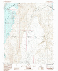
1984 Map of Meadview North
USGS Topo · Published 1984About this map
Lake Mead National Recreation Area dominates this early 1980s landscape, where the rising waters of the Colorado River basin meet the arid reaches of the Mojave. The settlement of Meadview serves as a focal point near the southern edge, positioned just above the expansive Grapevine Mesa. The shoreline is intricately detailed, revealing numerous inlets such as Wagon Trail Bay, South Cove, and Crappie Cove, which reflect the recreational development of the era. The mapping of Pearce Ferry and the nearby Landing Field suggests the area's importance as a remote access point for river travelers and aviators alike. To the east, the terrain rises sharply into Pearce Mesa, cut by the deep path of Grapevine Canyon. This survey captures the transition from high desert plateau to the managed waters of the reservoir, including small but vital landmarks like Grapevine Spring and a lonely Water Tank.
Find a feature on this map
27 named features on this map. Tap any name to fly to it.
Don’t see what you’re looking for? This feature index may not catch every label — zoom into the map to look around manually.
Map Details
Editions of this 1984 Meadview North Map
This is the sole edition of this map. No revisions or reprints were ever made.
Other maps of this area

1886 · Diamond Creek
USGS Topo · 1:250,000

1886 · Camp Mohave
USGS Topo · 1:250,000

1886 · Saint Thomas
USGS Topo · 1:250,000

1886 · Mt. Trumbull
USGS Topo · 1:250,000

1892 · Diamond Creek
USGS Topo · 1:250,000

1892 · Mt. Trumbull
USGS Topo · 1:250,000

1892 · Camp Mohave
USGS Topo · 1:250,000

1893 · Saint Thomas
USGS Topo · 1:250,000

1926 · Bonelli
USGS Topo · 1:96,000

1942 · Camp Mohave
USGS Topo · 1:250,000