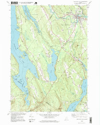
1995 Map of Mechanic Falls
USGS Topo · Published 1999About this map
The Little Androscoggin River carves through the landscape of the late 20th century, anchoring the industrial and community life of Mechanic Falls. This survey illustrates a complex transition between the tight-knit settlement of Minot and the recreational shorelines of Thompson Lake and Tripp Pond. The presence of the Grand Trunk RR line running parallel to the river highlights the historical corridor that fueled local growth.
Find a feature on this map
103 named features on this map. Tap any name to fly to it.
Don’t see what you’re looking for? This feature index may not catch every label — zoom into the map to look around manually.
Map Details
Editions of this 1995 Mechanic Falls Map
This is the sole edition of this map. No revisions or reprints were ever made.
Other maps of this area

1894 · Gray
USGS Topo · 1:62,500

1896 · Norway
USGS Topo · 1:62,500

1896 · Sebago
USGS Topo · 1:62,500

1898 · Gray
USGS Topo · 1:62,500

1908 · Poland
USGS Topo · 1:62,500

1940 · Poland
USGS Topo · 1:62,500

1942 · Poland
USGS Topo · 1:62,500

1942 · Gray
USGS Topo · 1:62,500

1942 · Sebago Lake
USGS Topo · 1:62,500

1943 · Sebago Lake
USGS Topo · 1:62,500