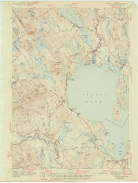
1943 Map of Sebago Lake
USGS Topo · Published 1943About this map
Sebago Lake and the surrounding Cumberland County townships appear here during the early 1940s, characterized by a complex network of waterways and early vacation infrastructure. The historic Songo Lock connects Brandy Pond and the Songo River, facilitating passage through the region's connected basins. On the southern shore, the Maine Central Railroad serves the corridor near Steep Falls and East Baldwin Mattocks Sta, while local educational landmarks like Potter Academy and Hawthorne Sch anchor the small inland settlements. The map highlights the early development of Sebago Lake State Park at the mouth of the Songo, alongside several prominent peaks including Douglas Mtn and Bald Pate Mtn. This survey captures the area just as it was becoming a premier destination, balancing active rail commerce with established rural schools and cemeteries like Friendship Cem.
Find a feature on this map
109 named features on this map. Tap any name to fly to it.
Don’t see what you’re looking for? This feature index may not catch every label — zoom into the map to look around manually.
Map Details
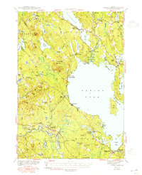
Editions of this 1943 Sebago Lake Map
3 editions found

Other maps of this area

1891 · Portland
USGS Topo · 1:62,500

1891 · Buxton
USGS Topo · 1:62,500

1891 · Newfield
USGS Topo · 1:62,500

1892 · Buxton
USGS Topo · 1:62,500

1893 · Portland
USGS Topo · 1:62,500

1893 · Buxton
USGS Topo · 1:62,500

1893 · Newfield
USGS Topo · 1:62,500

1894 · Gray
USGS Topo · 1:62,500

1896 · Norway
USGS Topo · 1:62,500

1896 · Sebago
USGS Topo · 1:62,500