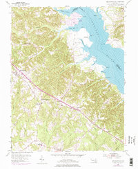
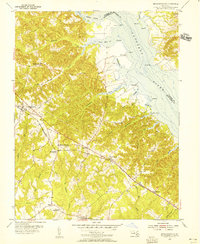
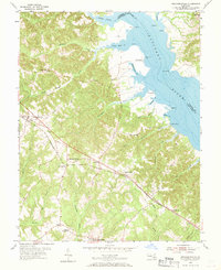
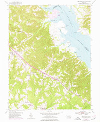
1953 Map of Mechanicsville
USGS Topo · Published 1976About this map
The Patuxent River defines the northeastern boundary of this landscape, where the tides meet the shores of Saint Marys Co, Charles Co, and Calvert Co. Inland, the terrain is a network of ridges and drainages like Killpeck Creek and Persimmon Creek that flow toward the river. The primary settlement of Mechanicsville serves as a hub for the surrounding rural communities of Huntersville, Oraville, and Oakville. The map captures a moment of transition in the 1970s, with purple photorevisions highlighting newer developments such as the residential grid at Golden Beach and the Landing Strip near Forrest Hall. Educational and spiritual centers are visible at St Josephs Sch and Brent High Sch, illustrating the dispersed yet connected nature of Southern Maryland's mid-century society.
Find a feature on this map
49 named features on this map. Tap any name to fly to it.
Don’t see what you’re looking for? This feature index may not catch every label — zoom into the map to look around manually.
Map Details
Editions of this 1953 Mechanicsville Map
4 editions found
Other maps of this area

1892 · Leonardtown
USGS Topo · 1:62,500

1892 · Prince Frederick
USGS Topo · 1:62,500

1892 · Brandywine
USGS Topo · 1:62,500

1894 · Wicomico
USGS Topo · 1:62,500

1895 · Prince Frederick
USGS Topo · 1:62,500

1895 · Wicomico
USGS Topo · 1:62,500

1895 · Brandywine
USGS Topo · 1:62,500

1895 · Leonardtown
USGS Topo · 1:62,500

1895 · Nomini
USGS Topo · 1:125,000

1898 · Nomini
USGS Topo · 1:125,000