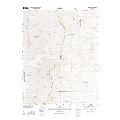
2013 Map of Medano Pass
USGS Topo · Published 2013About this map
Medano Pass serves as a critical geographic divide on this survey, marking the intersection where the borders of Saguache, Huerfano, and Alamosa counties converge. The landscape is dominated by the sprawling boundaries of the Great Sand Dunes National Park and the adjacent Great Sand Dunes National Preserve, while the eastern portion falls within the San Isabel National Forest. High peaks like Mount Herard and Mount Zwischen anchor the high-elevation terrain, overlooking a network of drainages such as Medano Creek and the seasonally varying Dry Lake. Human management of this arid environment is evident through features like the Hudson Ditch, Medano Ditch, and McKinley Clay Reservoir. Deeply incised drainages including Big South Canyon, Horse Canyon, and Poison Canyon illustrate the complex erosion patterns characteristic of the Sangre de Cristo Range's western slopes.
Find a feature on this map
38 named features on this map. Tap any name to fly to it.
Don’t see what you’re looking for? This feature index may not catch every label — zoom into the map to look around manually.
Map Details
Editions of this 2013 Medano Pass Map
This is the sole edition of this map. No revisions or reprints were ever made.
Other maps of this area

1889 · Huerfano Park
USGS Topo · 1:125,000

1892 · Huerfano Park
USGS Topo · 1:125,000

1954 · Trinidad
USGS Topo · 1:250,000

1955 · Trinidad
USGS Topo · 1:250,000

1958 · Trinidad
USGS Topo · 1:250,000

1959 · Trinidad
USGS Topo · 1:250,000
1960 · Beck Mountain
USGS Topo · 1:24,000
1960 · Devils Gulch
USGS Topo · 1:24,000

1965 · Zapata Ranch
USGS Topo · 1:24,000

1967 · Mosca Pass
USGS Topo · 1:24,000