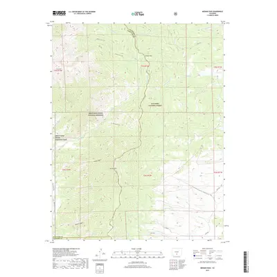
2019 Map of Medano Pass
USGS Topo · Published 2019About this map
Medano Pass serves as a critical geographic transition point between the high mountains and the expansive dunefields of southern Colorado. This 2019 survey captures the convergence of the San Isabel National Forest, Great Sand Dunes National Preserve, and Great Sand Dunes National Park. The landscape is defined by high peaks like Mt Herard and Mt Zwischen, with drainage patterns including the intricate headwaters of Medano Cr and its tributaries. Human engineering is visible through the presence of the Hudson Ditch and Medano Ditch, reflecting water management efforts in this high-elevation environment. Access to the interior is documented via the Medano Lake Trail and the Sand Ramp Trail, while the surrounding terrain is deeply incised by notable landforms such as Big South Canyon and Sawmill Canyon.
Find a feature on this map
39 named features on this map. Tap any name to fly to it.
Don’t see what you’re looking for? This feature index may not catch every label — zoom into the map to look around manually.
Map Details
Editions of this 2019 Medano Pass Map
This is the sole edition of this map. No revisions or reprints were ever made.
Other maps of this area

1889 · Huerfano Park
USGS Topo · 1:125,000

1892 · Huerfano Park
USGS Topo · 1:125,000

1954 · Trinidad
USGS Topo · 1:250,000

1955 · Trinidad
USGS Topo · 1:250,000

1958 · Trinidad
USGS Topo · 1:250,000

1959 · Trinidad
USGS Topo · 1:250,000
1960 · Beck Mountain
USGS Topo · 1:24,000
1960 · Devils Gulch
USGS Topo · 1:24,000

1965 · Zapata Ranch
USGS Topo · 1:24,000

1967 · Mosca Pass
USGS Topo · 1:24,000