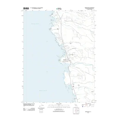
2012 Map of Mendocino
USGS Topo · Published 2012About this map
Mendocino and its neighboring coastal hamlets sit atop the wave-carved bluffs of the Northern California coast, where the Big River meets Mendocino Bay. This landscape is defined by its deep coastal ravines, including Russian Gulch, Jack Peters Gulch, and Slaughterhouse Gulch, which cut through the headlands. The map reveals a cluster of 19th-century settlement patterns, from the village grid of Mendocino to the timber-era origins of Caspar and Little River. Local history is preserved in several burial grounds, including Hillcrest Cem, Evergreen Cem, and the Little River Cem. Economic transitions are visible in the contrast between old resource-extraction routes like Caspar Logging Rd and modern infrastructure such as the Little River Airport. Large protected areas, including Russian Gulch State Park and Van Damme Beach, flank the settlements, securing the coastal interface between the Pacific Ocean and the redwood-forested interior.
Find a feature on this map
68 named features on this map. Tap any name to fly to it.
Don’t see what you’re looking for? This feature index may not catch every label — zoom into the map to look around manually.
Map Details
Editions of this 2012 Mendocino Map
This is the sole edition of this map. No revisions or reprints were ever made.
Other maps of this area

1920 · Glenblair
USGS Topo · 1:62,500

1920 · Fort Bragg
USGS Topo · 1:62,500

1943 · Glenblair
USGS Topo · 1:62,500

1943 · Fort Bragg
USGS Topo · 1:62,500

1943 · Albion
USGS Topo · 1:62,500

1943 · Navarro
USGS Topo · 1:62,500

1944 · Saddle Point
USGS Topo · 1:62,500

1957 · Ukiah
USGS Topo · 1:250,000

1960 · Ukiah
USGS Topo · 1:250,000
1960 · Elk
USGS Topo · 1:24,000