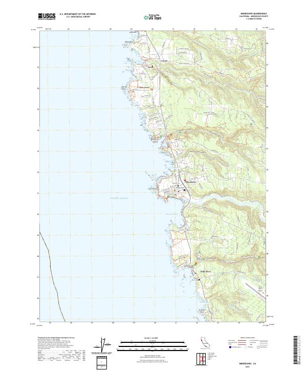
2021 Map of Mendocino
USGS Topo · Published 2021About this map
Mendocino anchors this coastal stretch of the Pacific, where the mouth of the Big River defines the local topography. This 2021 update shows the modern footprint of settlements like Caspar, Pine Grove, and Little River amidst a complex network of canyons and gulches. The interior is characterized by extensive recreational and conservation areas, including Russian Gulch State Park and Van Damme State Park, which are marked by deep incisions like Jack Peters Gulch and Fern Canyon. Along the jagged shoreline, marine features such as Goat Island, Caspar Point, and the Lighthouse at Cabrillo Point illustrate the maritime navigation hazards of the region. Local history is preserved through several dedicated burial grounds, notably Evergreen Cem, Hillcrest Cem, and Caspar Cem, providing vital reference points for genealogists tracing families in these coastal timber and fishing communities.
Find a feature on this map
140 named features on this map. Tap any name to fly to it.
Don’t see what you’re looking for? This feature index may not catch every label — zoom into the map to look around manually.
Map Details
Editions of this 2021 Mendocino Map
This is the sole edition of this map. No revisions or reprints were ever made.
Other maps of this area

1920 · Glenblair
USGS Topo · 1:62,500

1920 · Fort Bragg
USGS Topo · 1:62,500

1943 · Glenblair
USGS Topo · 1:62,500

1943 · Fort Bragg
USGS Topo · 1:62,500

1943 · Albion
USGS Topo · 1:62,500

1943 · Navarro
USGS Topo · 1:62,500

1944 · Saddle Point
USGS Topo · 1:62,500

1957 · Ukiah
USGS Topo · 1:250,000

1960 · Ukiah
USGS Topo · 1:250,000
1960 · Elk
USGS Topo · 1:24,000