
1962 Map of Merced Falls
USGS Topo · Published 1964About this map
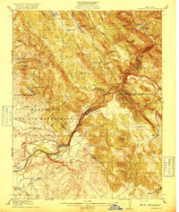
The gold-bearing foothills of the Sierra Nevada come into sharp focus through a network of mines and early hydraulic works. Mining activity is densely recorded across Penon Blanco Ridge and the surrounding canyons, with sites such as the Mitchell Mine, Solambo Mine, and Forty-nine Mine marking the region's industrial footprint. Near the Merced River, the landscape is fundamentally altered by dredge tailings and water management infrastructure, including the Snelling Diversion Dam and the Powerhouse at Merced Falls.
Find a feature on this map
100 named features on this map. Tap any name to fly to it.
Don’t see what you’re looking for? This feature index may not catch every label — zoom into the map to look around manually.
Map Details
Editions of this 1962 Merced Falls Map
This is the sole edition of this map. No revisions or reprints were ever made.
Other maps of this area

1893 · Sonora
USGS Topo · 1:125,000

1896 · Sonora
USGS Topo · 1:125,000

1897 · Sonora
USGS Topo · 1:125,000

1898 · Sonora
USGS Topo · 1:125,000

1913 · Dickenson
USGS Topo · 1:31,680

1915 · La Grange
USGS Topo · 1:24,000

1916 · Three Tree Flat
USGS Topo · 1:31,680

1916 · Hopeton
USGS Topo · 1:31,680

1916 · Cooperstown
USGS Topo · 1:31,680
1916 · Copperopolis
USGS Topo · 1:62,500