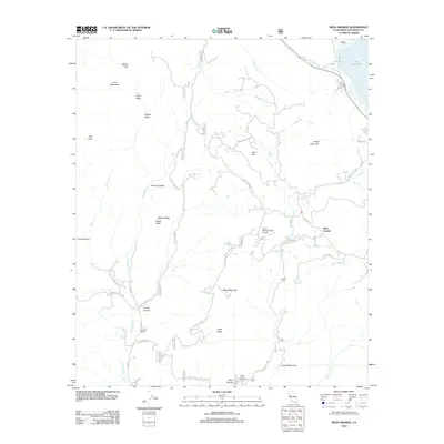
2012 Map of Mesa Grande
USGS Topo · Published 2012About this map
Mesa Grande and the surrounding high country of San Diego County are defined by a network of ranching corridors and rugged drainage basins in this 2012 survey. The northeastern corner is dominated by the waters of Lake Henshaw, where the San Luis Rey River enters the landscape. Much of the region is mapped through its remote access points, including the Lusardi Truck Trl and Mesa Grande Truck Trl, which connect the various valleys and peaks. Local infrastructure is sparse but notable, including the Loma Madera Ranch Airport and the Black Canyon Campground located near the southern margin. Notable landmarks such as Washtub Falls and Black Mountain Spring provide specific points of interest for those tracking water sources and historical recreation spots in this high-elevation terrain. Named family and ranching sites like Almond Ranch and Davis Ranch Rd offer clues to the enduring agricultural character of Temescal Valley and Organ Valley.
Find a feature on this map
49 named features on this map. Tap any name to fly to it.
Don’t see what you’re looking for? This feature index may not catch every label — zoom into the map to look around manually.
Map Details
Editions of this 2012 Mesa Grande Map
This is the sole edition of this map. No revisions or reprints were ever made.
Other maps of this area

1903 · Ramona
USGS Topo · 1:125,000

1904 · Southern California Sheet No. 2
USGS Topo · 1:250,000

1939 · Warner Springs
USGS Topo · 1:62,500

1939 · Santa Ysabel
USGS Topo · 1:62,500

1939 · Palomar Mountain
USGS Topo · 1:62,500

1942 · Ramona
USGS Topo · 1:62,500

1943 · Santa Ysabel
USGS Topo · 1:62,500

1943 · Warner Springs
USGS Topo · 1:62,500

1947 · Ramona
USGS Topo · 1:62,500

1947 · Santa Ana
USGS Topo · 1:250,000