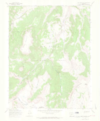
1967 Map of Mesa Mountain
USGS Topo · Published 1969About this map
Rio Grande National Forest and the high ridges of the La Garita Mountains dominate this 1967 field-checked survey of the Saguache and Mineral County line. The map captures a landscape defined by seasonal movement and extraction, where the La Garita Stock Driveway and other Stock Driveway routes trace through the high country alongside an intricate network of Pack Trail and Jeep Trail paths. High-altitude mining history is represented by the Sky City Mine and several other unnamed Mines located near the headwaters of Wannamaker Creek. The hydrology of the region is exceptionally detailed, showing the convergence of the Lake Fork Saguache Creek, South Fork Saguache Creek, and Deep Creek, all of which feed into the primary Saguache Creek drainage. Geographic markers like Sheep Mountain and the water at Laguna Hilda provide fixed reference points within the expansive La Garita Wilderness.
Find a feature on this map
27 named features on this map. Tap any name to fly to it.
Don’t see what you’re looking for? This feature index may not catch every label — zoom into the map to look around manually.
Map Details
Editions of this 1967 Mesa Mountain Map
3 editions found
Other maps of this area

1914 · Creede
USGS Topo · 1:125,000

1916 · Creede
USGS Topo · 1:125,000

1945 · Durango
USGS Topo · 1:250,000

1953 · Durango
USGS Topo · 1:250,000

1954 · Durango
USGS Topo · 1:250,000

1956 · Montrose
USGS Topo · 1:250,000

1959 · Montrose
USGS Topo · 1:250,000

1959 · Creede
USGS Topo · 1:62,500

1960 · Montrose
USGS Topo · 1:250,000

1961 · Durango
USGS Topo · 1:250,000