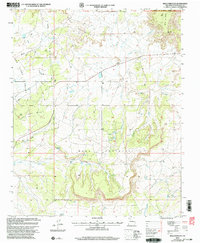
2002 Map of Mesa Portales
USGS Topo · Published 2003About this map
Santa Fe National Forest lands dominate this high-desert landscape in Sandoval County, defined by the massive uplift of Mesa Portales and Mesa de Cuba. The terrain is characterized by a complex network of dry washes and seasonal water sources, including Arroyo Chijuillita and Arroyo Jarido. In an environment where water is a vital resource, the map identifies specific points of interest such as Ojo de Gutierrez, Moreno Spring, and Smoky Spring. This 2002 revision reflects the intersection of natural topography and industrial activity, marked by numerous Drill Holes and a major Pipeline cutting through the San Isidro Valley. A small Cem and various corrals suggest the enduring presence of ranching and local settlement amidst the mesas.
Find a feature on this map
24 named features on this map. Tap any name to fly to it.
Don’t see what you’re looking for? This feature index may not catch every label — zoom into the map to look around manually.
Map Details
Editions of this 2002 Mesa Portales Map
This is the sole edition of this map. No revisions or reprints were ever made.
Other maps of this area

1883 · Mt. Taylor
USGS Topo · 1:250,000

1886 · Mt. Taylor
USGS Topo · 1:250,000

1889 · Largo
USGS Topo · 1:250,000

1890 · Jemes
USGS Topo · 1:125,000

1892 · Jemes
USGS Topo · 1:125,000

1892 · Mt. Taylor
USGS Topo · 1:250,000

1895 · Largo
USGS Topo · 1:250,000

1899 · Mt. Taylor
USGS Topo · 1:250,000

1909 · Gallina
USGS Topo · 1:125,000

1939 · La Ventana
USGS Topo · 1:62,500