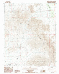
1985 Map of Mesquite Mountains
USGS Topo · Published 1985About this map
Mesquite Mountains define the high ground of this high-desert quadrangle, where the steep topography of the range gives way to the broad basin of Shadow Valley in the south. The 1985 survey illustrates a landscape primarily shaped by resource extraction and transportation, marked by numerous Prospect sites and a Borrow Pit indicating early exploration or road maintenance activity. Kingston Road and Excelsior Mine Road provide the primary access through the desert floor, converging near the gap at Winters Pass. This provisional edition captures the corridor's infrastructure in the mid-1980s, documenting the precise placement of desert tracks and mining claims within the public land survey system.
Find a feature on this map
13 named features on this map. Tap any name to fly to it.
Don’t see what you’re looking for? This feature index may not catch every label — zoom into the map to look around manually.
Map Details
Editions of this 1985 Mesquite Mountains Map
This is the sole edition of this map. No revisions or reprints were ever made.
Other maps of this area

1910 · Ivanpah
USGS Topo · 1:250,000

1912 · Ivanpah
USGS Topo · 1:250,000

1942 · Ivanpah
USGS Topo · 1:250,000

1947 · Kingman
USGS Topo · 1:250,000

1948 · Kingman
USGS Topo · 1:250,000

1954 · Kingman
USGS Topo · 1:250,000

1955 · Kingman
USGS Topo · 1:250,000

1955 · Kingston Peak
USGS Topo · 1:62,500

1956 · Clark Mountain
USGS Topo · 1:62,500

1956 · Shenandoah Peak
USGS Topo · 1:62,500