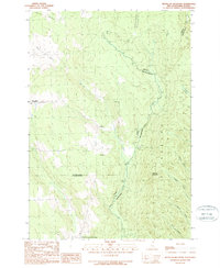
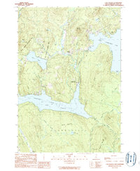
1989 Map of Metallak Mountain
USGS Topo · Published 1989About this map
Halls Stream serves as the international boundary between Pittsburg, New Hampshire, and the Province of Quebec on this late twentieth-century survey. The landscape is defined by the sharp rise of Metallak Mountain and a network of drainages feeding the border waters, including Jobbers Brook, Schoppe Brook, and Leighton Brook. To the west, the Canadian landscape is dotted with several small settlements and rural nodes such as Saint-Malo, Malvina, and Saint-Venant-de-Hereford. This survey illustrates the intricate intersection of international, provincial, and county lines, such as where Coos County meets the MRC de Compton. The cartography provides specific geographic details for these remote borderlands, tracing the headwaters of the Rivière Clifton and Ruisseau Chabot as they flow through the townships of Auckland and Hereford.
Find a feature on this map
23 named features on this map. Tap any name to fly to it.
Don’t see what you’re looking for? This feature index may not catch every label — zoom into the map to look around manually.
Map Details
Editions of this 1989 Metallak Mountain Map
This is the sole edition of this map. No revisions or reprints were ever made.
Other maps of this area

1925 · Indian Stream
USGS Topo · 1:48,000

1926 · Indian Stream
USGS Topo · 1:62,500

1927 · Indian Stream
USGS Topo · 1:62,500

1949 · Jackman
USGS Topo · 1:250,000

1963 · Jackman
USGS Topo · 1:250,000

1966 · Sherbrooke
USGS Topo · 1:250,000
1976 · Sherbrooke
USGS Topo · 1:250,000
1986 · Sherbrooke
USGS Topo · 1:100,000
1989 · Pittsburg
USGS Topo · 1:24,000
1989 · Lake Francis
USGS Topo · 1:24,000