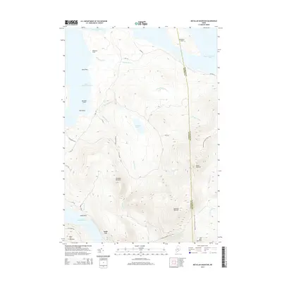
2014 Map of Metallak Mountain
USGS Topo · Published 2014About this map
Metallak Mountain stands as the central landmark in this high-elevation Maine landscape, situated where the borders of Oxford and Franklin counties meet. The area is defined by the massive bodies of Mooselookmeguntic Lake to the north and the connected Upper Richardson and Lower Richardson lakes to the west. This territory remains largely focused on outdoor recreation and wilderness conservation, evidenced by the presence of the Appalachian National Scenic Trail winding across the eastern ridges of Bemis Mountain and Elephant Mountain. At the southern tip of the Lower Richardson Lake, the small settlement of South Arm serves as a critical access point for water-based travel and logging roads like S Arm Rd. The intricate drainage system, featuring Metallak Stream, Metallak Brook, and Metallak Pond, illustrates the complex hydrology that feeds into the region's famous lake chain.
Find a feature on this map
38 named features on this map. Tap any name to fly to it.
Don’t see what you’re looking for? This feature index may not catch every label — zoom into the map to look around manually.
Map Details
Editions of this 2014 Metallak Mountain Map
This is the sole edition of this map. No revisions or reprints were ever made.
Other maps of this area

1927 · Rumford
USGS Topo · 1:48,000

1930 · Rumford
USGS Topo · 1:62,500

1933 · Rangeley
USGS Topo · 1:48,000

1939 · Rangeley
USGS Topo · 1:62,500

1940 · Oquossoc
USGS Topo · 1:62,500

1942 · Oquossoc
USGS Topo · 1:62,500

1943 · Old Speck Mtn
USGS Topo · 1:62,500

1945 · Old Speck Mtn
USGS Topo · 1:62,500

1949 · Rangeley
USGS Topo · 1:62,500

1950 · Lewiston
USGS Topo · 1:250,000