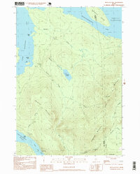
1997 Map of Metallak Mtn
USGS Topo · Published 1999About this map
Metallak Mountain and Elephant Mountain anchor this heavily forested topography in western Maine, defining a landscape shaped by high ridges and the expansive waters of the Rangeley Lakes. The map illustrates a transitional period in the late 20th century where traditional land use, represented by Sand & Gravel Pits, meets modern recreational preservation along the Appalachian National Scenic Trail. The trail winds across the eastern slopes of Bemis Mountain, providing a distinct contrast to the active waterways and points like Black Point and Bailey Point.
Find a feature on this map
28 named features on this map. Tap any name to fly to it.
Don’t see what you’re looking for? This feature index may not catch every label — zoom into the map to look around manually.
Map Details
Editions of this 1997 Metallak Mtn Map
This is the sole edition of this map. No revisions or reprints were ever made.
Other maps of this area

1927 · Rumford
USGS Topo · 1:48,000

1930 · Rumford
USGS Topo · 1:62,500

1933 · Rangeley
USGS Topo · 1:48,000

1939 · Rangeley
USGS Topo · 1:62,500

1940 · Oquossoc
USGS Topo · 1:62,500

1942 · Oquossoc
USGS Topo · 1:62,500

1943 · Old Speck Mtn
USGS Topo · 1:62,500

1945 · Old Speck Mtn
USGS Topo · 1:62,500

1949 · Rangeley
USGS Topo · 1:62,500

1950 · Lewiston
USGS Topo · 1:250,000