1968 Map of Middle Amana
USGS Topo · Published 1971About this map
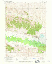
The Iowa River valley serves as the central corridor for this 1968 study, where the distinctive communal settlement patterns of the Amana Colonies are clearly visible across the landscape. Clusters of development at West Amana, High Amana, and Middle Amana sit north of the river, while South Amana, Upper South Amana, and Homestead anchor the southern portion of the quadrangle. This era shows the valley before the full impact of inundation, with the Coralville Reservoir beginning to influence the eastern drainage. Transport networks are dominated by two major rail lines, the Chicago Rock Island and Pacific and the Chicago Milwaukee St Paul and Pacific, which parallel the river's course. Local history details include the Maas Cem near the riverbanks and the Swedenborg Ch in the northern hills of St Clair township.
Find a feature on this map
29 named features on this map. Tap any name to fly to it.
Don’t see what you’re looking for? This feature index may not catch every label — zoom into the map to look around manually.
Map Details
Editions of this 1968 Middle Amana Map
This is the sole edition of this map. No revisions or reprints were ever made.
Other maps of this area

1888 · Amana
USGS Topo · 1:62,500

1889 · Amana
USGS Topo · 1:62,500

1891 · Oxford
USGS Topo · 1:62,500

1894 · Oxford
USGS Topo · 1:62,500

1899 · Amana
USGS Topo · 1:62,500

1903 · Fairfax
USGS Topo · 1:125,000

1954 · Des Moines
USGS Topo · 1:250,000

1956 · Des Moines
USGS Topo · 1:250,000

1957 · Des Moines
USGS Topo · 1:250,000

1958 · Davenport
USGS Topo · 1:250,000