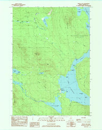
1984 Map of Middle Dam
USGS Topo · Published 1985About this map
Lower Richardson Lake and Upper Lake Richardson dominate this 1980s landscape, connected by the narrow passage of The Narrows. The settlement of Middle Dam sits at the western edge of the lower lake, serving as a gateway to the Rapid River and the nearby Pond in the River. This remote stretch of Oxford County is defined by its extensive water network and topographical markers like Moose Mtn and Johnson Mtn, illustrating the complex jurisdictional boundaries of Magalloway Plantation and Richardsontown. The presence of 4WD trails and numerous named coves such as Spaulding Cove and Halfmoon Cove suggests a geography shaped by seasonal recreation and timber management rather than dense urbanization. From Umbagog Lake in the west to the southern reaches of Township C, the map captures the transition of the Maine wilderness before the digital era.
Find a feature on this map
41 named features on this map. Tap any name to fly to it.
Don’t see what you’re looking for? This feature index may not catch every label — zoom into the map to look around manually.
Map Details
Editions of this 1984 Middle Dam Map
This is the sole edition of this map. No revisions or reprints were ever made.
Other maps of this area

1930 · Milan
USGS Topo · 1:62,500

1930 · Errol
USGS Topo · 1:62,500

1933 · Milan
USGS Topo · 1:62,500

1934 · Errol
USGS Topo · 1:62,500

1934 · Milan
USGS Topo · 1:62,500

1940 · Oquossoc
USGS Topo · 1:62,500

1942 · Oquossoc
USGS Topo · 1:62,500

1943 · Old Speck Mtn
USGS Topo · 1:62,500

1945 · Old Speck Mtn
USGS Topo · 1:62,500

1950 · Lewiston
USGS Topo · 1:250,000