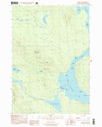
1997 Map of Middle Dam
USGS Topo · Published 1999About this map
Lower Richardson Lake and the Rapid River corridor define this region of Oxford County, where the settlement of Middle Dam serves as the focal point for water management and navigation between the lakes. The landscape is characterized by its complex shoreline, featuring Hardscrabble Island and numerous coves like Spaulding Cove and Cranberry Cove. The terrain rises sharply from the water at South Mountain and Moose Mtn, creating a high-relief environment dominated by the Magalloway Plantation and Upton territories. Historical transit is noted through the presence of Carry Ridge and Inlet Ridge, likely reflecting old portage routes used before modern 4WD roads reached the backcountry. Smaller bodies of water, including Pond in the River and Sunday Pond, are tucked into the drainages of Ash Brook and Birch Brook, illustrating the dense hydrological network that feeds into the larger Richardson and Umbagog Lake systems.
Find a feature on this map
38 named features on this map. Tap any name to fly to it.
Don’t see what you’re looking for? This feature index may not catch every label — zoom into the map to look around manually.
Map Details
Editions of this 1997 Middle Dam Map
This is the sole edition of this map. No revisions or reprints were ever made.
Other maps of this area

1930 · Milan
USGS Topo · 1:62,500

1930 · Errol
USGS Topo · 1:62,500

1933 · Milan
USGS Topo · 1:62,500

1934 · Errol
USGS Topo · 1:62,500

1934 · Milan
USGS Topo · 1:62,500

1940 · Oquossoc
USGS Topo · 1:62,500

1942 · Oquossoc
USGS Topo · 1:62,500

1943 · Old Speck Mtn
USGS Topo · 1:62,500

1945 · Old Speck Mtn
USGS Topo · 1:62,500

1950 · Lewiston
USGS Topo · 1:250,000