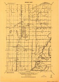
1918 Map of Middle River
USGS Topo · Published 1943About this map
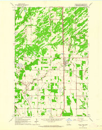
Middle River and the surrounding drainage basin of Marshall County are captured in this military compilation, showcasing a landscape defined by an extensive network of civil engineering projects. The map documents numerous numbered and lettered drainage canals, such as Jud. Ditch and Ditch No. 15, which were critical to the development of the Red River Valley’s agricultural potential during this era. These man-made channels intersect the natural path of the Old Thief River and Mud River, illustrating a period of active land reclamation and transformation.
Find a feature on this map
64 named features on this map. Tap any name to fly to it.
Don’t see what you’re looking for? This feature index may not catch every label — zoom into the map to look around manually.
Map Details
Editions of this 1918 Middle River Map
This is the sole edition of this map. No revisions or reprints were ever made.
Historical Maps of Middle River Through Time
7 maps found