
1903 Map of Middlebury
USGS Topo · Published 1956About this map
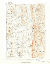
Middlebury and the surrounding townships of New Haven and Bristol define this landscape at the dawn of the twentieth century. The map illustrates a region transitioning from raw resource extraction to a more established agricultural and transit network, notably marked by the Bristol Orebed and another Orebed further north near Barnumtown. These sites of early industry are connected to the wider world by the Rutland railroad line and the Plank Road, which cuts across the central valley near Vergennes.
Find a feature on this map
71 named features on this map. Tap any name to fly to it.
Don’t see what you’re looking for? This feature index may not catch every label — zoom into the map to look around manually.
Map Details
Editions of this 1903 Middlebury Map
2 editions found
Other maps of this area

1894 · Port Henry
USGS Topo · 1:62,500

1894 · Ticonderoga
USGS Topo · 1:62,500

1895 · Willsboro
USGS Topo · 1:62,500

1896 · Ticonderoga
USGS Topo · 1:62,500

1898 · Port Henry
USGS Topo · 1:62,500

1902 · Ticonderoga
USGS Topo · 1:62,500

1902 · Brandon
USGS Topo · 1:62,500

1904 · Brandon
USGS Topo · 1:62,500

1905 · Middlebury
USGS Topo · 1:62,500

1906 · Burlington
USGS Topo · 1:62,500