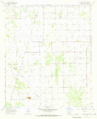
1965 Map of Midway Butte
USGS Topo · Published 1967About this map
Midway Butte rises above the high desert floor of southern Luna County in this mid-1960s topographic study. The landscape is defined by the ephemeral passage of Seventysix Draw, which winds through a terrain marked by scattered water sources and survey markers. A notable human corridor is the Hermanas Grade, a straight-line route cutting across the western portion of the map, suggesting the region's historic reliance on established ranching and transit paths. Near the center of the sheet, the Deming Base benchmark anchor indicates the area's importance for regional surveying and geodetic control. The presence of numerous Wells and several Gravel Pits underscores a rural economy dependent on subterranean water and local mineral extraction in an otherwise arid environment.
Find a feature on this map
8 named features on this map. Tap any name to fly to it.
Don’t see what you’re looking for? This feature index may not catch every label — zoom into the map to look around manually.
Map Details
Editions of this 1965 Midway Butte Map
This is the sole edition of this map. No revisions or reprints were ever made.
Other maps of this area

1899 · Deming
USGS Topo · 1:125,000

1915 · Deming
USGS Topo · 1:125,000

1917 · Hermanas
USGS Topo · 1:62,500

1917 · Columbus
USGS Topo · 1:62,500

1918 · Columbus
USGS Topo · 1:62,500

1918 · Hermanas
USGS Topo · 1:62,500

1920 · Columbus
USGS Topo · 1:62,500

1943 · Hermanas
USGS Topo · 1:62,500

1953 · El Paso
USGS Topo · 1:250,000

1955 · Las Cruces
USGS Topo · 1:250,000