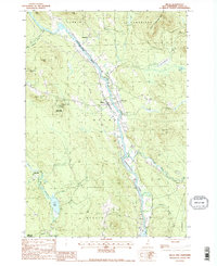
1988 Map of Milan
USGS Topo · Published 1988About this map
The Androscoggin River carves a deep valley through this North Country landscape, serving as the central artery for the small settlements of Dummer and Milan. In the late 1980s, the region's character was defined by a mix of forestry and light aviation, centered on the Berlin Airport and the sprawling borders of the White Mtn Nat Forest. The topography is dominated by prominent peaks such as Milan Hill, which features a Milan Hill Lookout Tower and its namesake Milan Hill State Park. To the west, the Upper Ammonoosuc River and its tributary Jericho Brook drain the hills near Copperville, where a series of Gravel Pits indicate local industrial activity. The presence of several Cem sites near the river valley provides valuable reference points for genealogists tracing family roots in this part of Coos County.
Find a feature on this map
35 named features on this map. Tap any name to fly to it.
Don’t see what you’re looking for? This feature index may not catch every label — zoom into the map to look around manually.
Map Details
Editions of this 1988 Milan Map
2 editions found
Other maps of this area

1893 · Mt. Washington
USGS Topo · 1:62,500

1893 · Gorham
USGS Topo · 1:62,500

1896 · Mt. Washington
USGS Topo · 1:62,500

1896 · Gorham
USGS Topo · 1:62,500

1930 · Milan
USGS Topo · 1:62,500

1930 · Percy
USGS Topo · 1:62,500

1933 · Milan
USGS Topo · 1:62,500

1934 · Percy
USGS Topo · 1:62,500

1934 · Milan
USGS Topo · 1:62,500

1935 · Mt. Washington
USGS Topo · 1:62,500